Last Updated:
2025-Q2
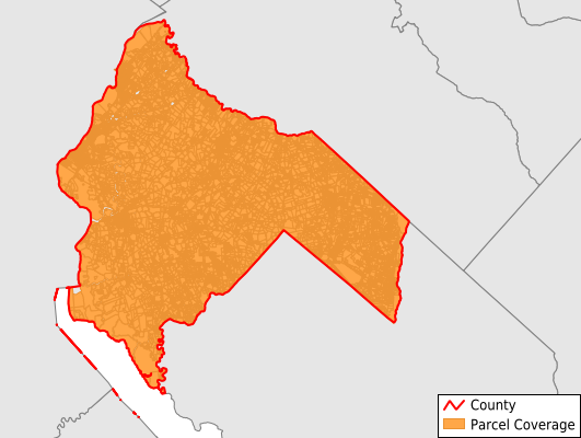
Parcels in County:
32,640
Parcel data available to download as a GDB, GeoPackage, Shapefile, Excel, CSV, or Google Earth KML file.
All purchased data comes with six months of access, including any updates, at no additional cost.
Key attribute coverage for Salem County
The percentage of Salem County parcels containing the following key attributes:
Owner: 95.7%
Parcel Number: 100%
Acreage (Calculated): 100%
Site Address: 95.7%
Mailing Address: 95.7%
All available attributes in Salem County
Parcel Number
Site Address
Owner
Transfer Date
Sale Price
Building Size
Land Use Code
Land Use Class
Zoning
Acreage (calculated)
Perimeter
Municipality
School District
Zip Code
Flood Zone
Flood Zone Subtype
Census Tract
Census Block Group
Census Block
Total Market Value
Land Market Value
Building Market Value
Coowner
Mail Address1
Mail Address3
Legal Desc1
Year Built
Buildings
Addr Sec Unit Num
Place Gnis Code
Land Cover
Elevation
Owner Occupied
Robust Id
Usps Residential
Alt Id 1
Crop Cover
Acreage Adjacent With Sameowner
Flood Zones
Nearest Transmission Line Dist Ft
Nearest Substation Dist Ft
Derived Geom Properties
Municipalities Respresented in Salem County
Elsinboro Township: 838
Lower Alloways Creek Township: 1,266
Quinton Township: 1,675
Alloway Township: 2,061
Pilesgrove Township: 2,007
Mannington Township: 1,179
Pennsville Township: 6,549
Carneys Point Township: 3,460
Oldmans Township: 1,385
Elmer Borough: 880
Penns Grove Borough: 1,817
Salem City: 2,318
Woodstown Borough: 1,453
Upper Pittsgrove Township: 1,840
Pittsgrove Township: 3,894
Save money when you buy data in bulk
We offer discounted pricing on county and state downloads.